Jon Lawrence

Walk 2: Blackaton Copse (2.1 miles)

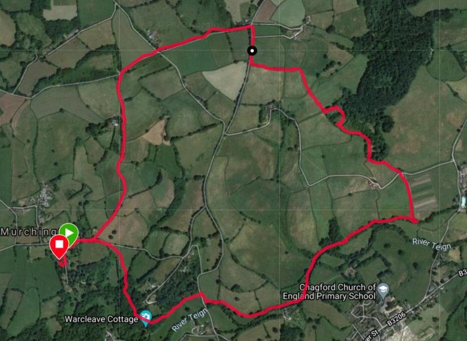
2.1 Miles, 55 minutes, Elevation gain 64m

walk2.jpg

Directions

Head west out of Murchington on the Gidleigh road. Pass the road to Higher Murchington but as you get to the top of the short hill take the track on your right (opposite the footpath down to the river). Follow the track past Hackfield Cottage to Fairview and head straight (slightly left) onto the road.

The view of Meldon from near Fairview

The view of Meldon from near Fairview

Follow this narrow lane for about a mile, joining a slightly larger road from the right as you descend. Note the fine view across the Blackaton Brook valley to Providence with its Bible Chapel and former School House. When you reach the bottom of the hill follow the road round to the left rather than crossing the brook and ascending the hill to Providence. The beautiful garden to your right belongs to the picture-postcard Blackaton House and is occassinally open as part of the National Garden scheme. Follow the road for about 200 metres, but before you get to Blackaton Bridge take the footpath into Blackaton Copse (WT) - crossing the stile - and follow the woodland path alongside Blackaton Brook. This is a lovely ancient wood with a couple of seats overlooking the brook and a series of paths, any of which will take you back to the Gidleigh Road. At the road, turn left and walk back to Murhcington - approximately a mile along a beutiful country lane.

Note: this is a lovely walk to do in reverse, especially at dusk when you may see Meldon lit by the evening sun as you appraoch Fairview on the edge of Murchington.

Mild Peril: not much - the roads are quiet, but do listen out for traffic on the narrow lanes.

Walk 5: Frenchbeer circuit (6.8 miles)

6.8 miles, 2 hours 40 mins, Elevation gain 287 m

Walk 5a.jpg

From Murchington head towards Chagford passing the chapel on your left and heading straight on (right) at the fork. As the Chagford road begins to drop steeply downhill take the footpath on your right into the field and follow the path downhill to Warcleave Wood. Walk through the wood - in May there are massed bluebells on both sides for much of its length. When you come to the road turn right and cross the ancient Chagford bridge. Follow the road past the kennels of the Mid Devon Hunt to the cross roads. Turn right and follow the road for about a mile towards Gidleigh Park. At first you walk alongside the leat for the old Chagford Wollen mills, later you will pass the magnificent Holystreet Manor and the sweeping gardens of Puggiestone (named after a large granite outcrop close by the river once thought to have Druid connections). Just after you have crossed Leigh Bridge, at the confluence of the south and north Teign rivers, leave the road and take the rough bridleway to the left which runs steeply up hill toTeigncombe.

Alternative - when the river is low this first section of the walk can be varied (and shortened) by leaving Murchington in the opposite (Gidleigh) direction and taking the bridleway on the left as you leave the hamlet. This drops down to a ford and a set of ancient stepping stones across the Teign. These can be slippy even in summer, but if you are feeling brave they give you quick access to the brideway to Teigncombe. After crossing the river follow the path up to the road. Turn left and walk along the road towards Chagford until you see the bridleway on your right at a sharp bend.

The ancient bridleway from Leigh Bridge to Teigncombe

The ancient bridleway from Leigh Bridge to Teigncombe

The footpath at Teigncombe which takes you cross country to Frenchbeer.

The footpath at Teigncombe which takes you cross country to Frenchbeer.

The path to Teigncombe rises almost continuously for about a mile, offering attractive views back towards Gidleigh at various points. The track becomes metalled when you come to the entrance to North Hill. When you come to the road proper turn right and follow the road up to the attractive settlement of Teigncombe. When the road turns sharply right keep straight on for a about twenty metres past Teigncombe Manor. Here there is a narrow path to the right, besides a house, which heads up to the open moor and Kestor Rock, but ignore this and instead take the Two Moors Way to your left through two small gates. This is an unprepossessing start to a wonderful section of the walk heading towards Frenchbeer.

Follow the path through a field, keeping to the hedge line. In the far corner the path crosses a small water course and heads into a dense wood of conifers and young birch. When you emerge at the top, cross the track and head into a large pasture field. This can be very muddy, especially as you exit into another wooded area. Sections of the path now follow a boardwalk across boggy ground. At Boldventure you need to look out for footpath signs which take you to the left of a newly fenced paddock. As you pass close by Ford, a Duchy property, you will see large banks of bamboo and in summer other invasive species including Himalayan Balsam. As you get closer to Frencbeer the views open up to the east across rich farmland to the hills of Meldon and Easdon. At Frencbeer, with its locally famous Turkey farm, you rejoin the road and turn left heading down to Yeo Farm. (At Frenchbeer the walk can be extended by instead crossing the road and continuing on the Two Moors Way to Teignworthy and Yardworthy and returning via Cullaton and Thorn). Pass Yeo Farm and follow the road right, crossing the South Teign river and rising uphill past the impressive Outer Down till you come to the settlement of Thorn. Here ignore the road to your right (to Cullaton) and head gently up hill to Waye Barton. At the main road turn left and then almost immediately keep left rather than heading down into Chagford on Manor Road (unless you fancy a pint in town). The road now offers magnificent views across Chagford to Drogo looking North-East, while if you look west you see the wooded Teign valley at Holystreet and Milfordleigh. You also get clear views back to St Olaves, with the granite walls standing out clearly on the hillside. Follow this road back down to Chagford Bridge and retrace your route through Warcleave Wood to Murhcington.

Walk 6: Along the Teign & up to Higher Withecombe (4 miles)

4 miles, 2 hours, Elevation gain 370 ft

Route of the walk courtesy of Garmin and Google Earth

Route of the walk courtesy of Garmin and Google Earth

Directions

The River Teign below Chagford Bridge

The River Teign below Chagford Bridge

From Murchington head past the former chapel towards Chagford (keep straight ahead rather than following the road left). At the top of an incline, before the road begins a steep drop, take the footpath to the right across the field to Warcleave Wood. After crossing a small stream, walk through the wood, past Warcleave Cottage (NT) hidden in the trees to the right, until you come out on to the road again. Turn right, but as you come to the ancient Chagford Bridge take the footpath on the left that follows the river downstream. Follow the river for about a mile. After a few hundred metres the building to your right is the historic Chagford Woollen Mill, note the mill leat flowing back into the Teign just beyond the factory block. The building has been skillfully reconstructed into six residential properties.

When you come to a weir the footpath leaves the river, following instead the course of Rushford Mill leat (which now supplies the water for Chagford’s outdoor swimming pool (May to September)). Follow this leat for a few hundred metres through a large field with a red-roofed farm on the horizon (Chagfood Community farm). Before you come to a footbridge which crosses the leat take the footpath to the left which follows the hedge line of the big field. At the top you will cross the track which leads to the red-roofed buildings. Keep ahead to skirt around the edge of a small wooded area. If you are lucky you will meet the inquisitive Chagfarm pigs in their large wooded enclosure.

Rare breed pigs eating nettles in their enclosure at the southern end of Rushford Wood.

Rare breed pigs eating nettles in their enclosure at the southern end of Rushford Wood.

Keeping the pigs to your right, the path rises quite steeply, bending first to the right. The goat enclosure should now be on your right, with high fencing and spacious housing. As you leave the goats behind and bend left the going can get quite boggy as you head north-west across a rough field. At the end of this field look out for a dilapidated footpath sign and stile into a field to the left. Follow the path up hill, with the hedge to your right. Cross the sunken track which connects Lower Withecombe (left) to Rushford Wood, climbing the stile on the other side. The path now crosses two fields heading north-west. The views back towards Chagford are spectacular from here - so do turn round. Higher Withecombe farm is straight ahead when you cross into the third field. Instead of continuing towards it, the footpath turns left (west). Follow it, keeping to the hedge, till you come to the road (it can be very muddy here). Turn right and head towards Monks Withecombe gallery (on the corner). At the gallery, turn left and follow the road up to Way Down - keeping straight at the crossroads (Waye Cross). At the top, by the Way Down transmitter, take the left and follow the road south, past St John’s till you are back in Murchington. The views to the west - towards Gidleigh Park - are impressive.

Points of Interest: compared with its upland stretches above Chagford Bridge, the River Teign flows gently at this point. This is a prime trout fishing river, managed by the Upper Teign Fishing Assocation since the 1860s. Salmon and sea trout also come up the river to spawn (now Dartmoor’s heavy metal mining no longer renders the river inhospitable for these magnificent creatures). This is also a good place to spot river-loving bird species such as dippers, grey wagtails and if you are fortunate, the iridescent kingfisher. Also look out for the stately goosander - a large diver-like duck that has recently expanded into the area.

Mild peril: not much - the river and the fields around Lower and Higher Withecombe can get very muddy in winter/spring. Some signposts are easy to miss.

Old gate and granite post at Lower Withecombe

Old gate and granite post at Lower Withecombe